
Warning: Undefined array key "hidden" in E:\www\smallcodes.com\wp-content\plugins\fusion-builder\shortcodes\fusion-gallery.php on line 756
Warning: Undefined array key "hidden" in E:\www\smallcodes.com\wp-content\plugins\fusion-builder\shortcodes\fusion-gallery.php on line 756
Warning: Undefined array key "hidden" in E:\www\smallcodes.com\wp-content\plugins\fusion-builder\shortcodes\fusion-gallery.php on line 756
Warning: Undefined array key "hidden" in E:\www\smallcodes.com\wp-content\plugins\fusion-builder\shortcodes\fusion-gallery.php on line 756
Warning: Undefined array key "hidden" in E:\www\smallcodes.com\wp-content\plugins\fusion-builder\shortcodes\fusion-gallery.php on line 756
Warning: Undefined array key "hidden" in E:\www\smallcodes.com\wp-content\plugins\fusion-builder\shortcodes\fusion-gallery.php on line 756
Toponymy
There is a specific branch in the SC lexicography system: toponymy. The systems for the cataloguing of toponymy are fundamental to assign a strong identity to the territories of minority languages: the use of traditional toponymy is often the first step towards the recognition of an autonomous linguistic identity.
Smallcodes uses two types of applications for toponymy consultation, with a different approach, although they are easily interoperable and can be connected to each other.
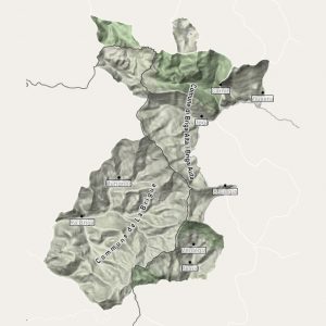
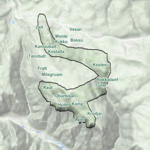
In the first case, the maps are georeferenced and navigable at different zoom levels – satellite and/or cartographic, with the toponymy in the traditional language complete. Each toponym can be associated with an in-depth sheet, which opens at the click of the user, with additional information on the selected location.
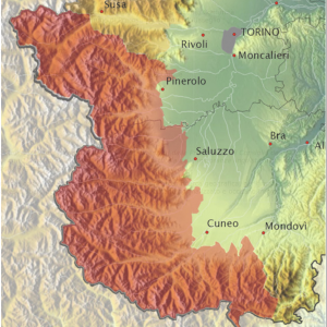
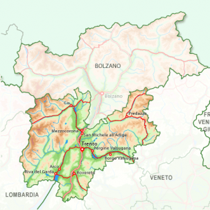
The second mode is a geographical search portal, for large linguistic areas, for mountain communities and for municipalities, in which for each location information is provided about the attestations in written sources, tourist information and precise geographical coordinates.
Geographic Maps
There are few things more fascinating and inspiring than a map, both for those who already know an area, for those who want to know it or want to regain possession of it. Umberto Eco wrote: “Maps not only make the world known, but also make you want to travel through it”.
SC, based on this principle, produces maps that represent a precise vision of the world: every small portion of the world, in fact, when it is represented with clarity and geographical fidelity becomes authentic and acquires an identity, reminding us of the need to defend and preserve our traditions and our languages with a projection towards modernity.
The maps produced by Smallcodes are available for consultation or sale.


